| Home Page | Buying | Maps | Books | Prints | Ephemera |
- Home Page
- Europe, the Continent
- Eastern & South Eastern Europe
- France
- Germany
- Iberia
- Italy
- Low Countries
- Mediterranean
- Russia
- Scandinavia
- Switzerland
1,500 maps reduced in price
All our maps are Originals, NOT modern reproductions
Now all our maps have thumbnails as well as larger images so finding what you want is quicker.
If you want several items, email me for a discount!
Email: don@theoldmapman.com
 British Possessions in Europe Geo. Philip c1907 - 35 x 23 cm Large coloured map of the Channel Islands, Malta & Gozo, Cyprus, Gibraltar and the Straits. Larger image Ref eur36 : £11 Return to Europe Index |
 Europe 1878. Bartholomew; Wm Collins c1875 - 22 x 15 cm An original antique coloured map. Larger image Ref eur33 : £8 Return to Europe Index |
 Europe at the beginning of the 6th Century. Bartholomew; Wm Collins c1875 - 22 x 15 cm An original antique coloured map. Larger image Ref eur26 : £8 Return to Europe Index |
 Europe at the beginning of the 9th Century. Bartholomew; Wm Collins c1875 - 22 x 15 cm Empire of Charlemagne. An original antique coloured map. Larger image Ref eur27 : £8 Return to Europe Index |
 Europe at the Dismemberment of the Carlovingia Empire. c1885 - 20.5 x 12.5 cm Original antique coloured map. Larger image Ref eur39 : £8 Return to Europe Index |
 Europe in the 12th Century. Bartholomew; Wm Collins c1875 - 22 x 15 cm An original antique coloured map. Larger image Ref eur29 : £8 Return to Europe Index |
 Europe in the middle of the 16th Century. Bartholomew; Wm Collins c1875 - 22 x 15 cm Period of the Reformation. An original antique coloured map. Larger image Ref eur30 : £8 Return to Europe Index |
 Europe latter part of the 10th Century. Bartholomew; Wm Collins c1875 - 22 x 15 cm An original antique coloured map. Larger image Ref eur28 : £8 Return to Europe Index |
 Europe under the Empire of Charlemagne. c1885 - 20.5 x 12.5 cm Original antique coloured map. Larger image Ref eur38 : £8 Return to Europe Index |
 Europe, Geological Blackie 1866 - 22 x 14 cm The Principal Geological Features. Hand-colouring of the Igneous periods and active volcanoes. Also shows the extent of the effects felt from the Lisbon Earthquake of 1756. Larger image Ref eur40 : £8 Return to Europe Index |
 Europe. Bartholomew; W & R Chambers 1868 - 26 x 22 cm An original antique coloured map with centrefold. Larger image Ref eur22 : £8 Return to Europe Index |
 Europe. Bartholomew; Wm Collins c1875 - 30 x 23 cm An original antique coloured map with centrefold. Larger image Ref eur23 : £8 Return to Europe Index |
 Europe. Wm MacKenzie c1880 - 28 x 23 cm An original antique coloured map with centrefold. Larger image Ref eur21 : £8 Return to Europe Index |
 Europe. General map. Geo. Philip c1907 - 48 x 35 cm Very large double page coloured map, with centrefold. Inset of Population. Larger image Ref eur34 : £12 Return to Europe Index |
 France & the Low Countries. Geo. Philip c1907 - 35 x 48 cm Very large double page coloured map, with centrefold. Larger image Ref eur37 : £12 Return to Europe Index |
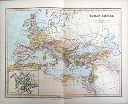
 Roman Empire AD 117. Wm, MacKenzie c1885 - 25.5 x 19.5 cm Original antique coloured map. Centrefold as issued. Larger image Ref eur41 : £8 Return to Europe Index |
 Roman Empire in the 4th Century. Bartholomew; Wm Collins c1875 - 22 x 15 cm An original antique coloured map. Larger image Ref eur25 : £8 Return to Europe Index |
 Roman Empire. Bartholomew; Wm Collins c1875 - 30 x 23 cm An original antique coloured map with centrefold. Larger image Ref eur24 : £8 Return to Europe Index |
||
| |||